Storms Roll Through North Dakota
July has been a busy month for storms in North Dakota, with many of them hitting the southern part of the state harder than other areas. Last week, the pattern moved more to northwest North Dakota bringing plentiful rain, winds and some hail. The pattern also caused schedule changes at the North Dakota State Fair with some acts moving up their performance time and the cancellation on the Indian Horse Relays.
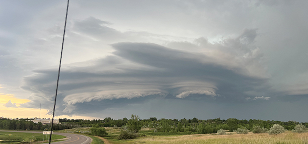
Pictured are some scenes from the storms that formed on Friday evening. These had what looked like two or more supercell storms merging to create high winds and heavy rains. Some of the pictures were taken by Cjea Paulson. She and her husband Steven were moving into their new place in Stanley. The pictures were taken in front of her new home on Adeline Drive. That includes the top photo of the storm over Stanley and the photo of the rainbow and lightning on Page 10. Others were taken by the Dale Kilen home, including the photo after the storm with the sun breaking through the clouds. More storms rolled through in the overnight hours on Saturday.
The National Weather Service issued a long range outlook last week that shows the active weather pattern is favored to continue with potential for localized heavy rainfall from the end of July into early August. There is a slight risk (20 to 40% chance) of heavy precipitation from July 31 through August 4 across North Dakota and the surrounding area.
While the placement and timing was uncertain at the time of the release on July 23, they said that residents should be prepared for the threat of heavy rainfall and localized flooding to continue through early August. The active and warm pattern favors a low, but persistent, risk of several thunderstorms.
The forecast also showed that although temperatures may briefly cool to below normal at the end of July, a rebound to above normal temperatures is slightly favored across the majority of North Dakota through August 6. This is the climatologically warmest time of the year, with average high temperatures in the lower to mid-80s across the state.
While the severe season is May through September in North Dakota, the peak of severe season is generally June and July, meaning we will gradually be trending towards less frequent severe thunderstorm days/periods.
On average, the last severe warning across North Dakota is September 22, while the latest has been November 4, 2008. The average last tornado warning across North Dakota is August 27, with the latest being November 1, 2000.