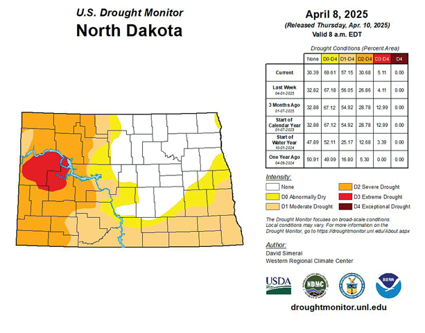
Drought Monitor Shows Severe To Extreme Conditions
The National Weather Service in Bismarck issued their most recent drought information on Thursday, Apr. 10. The report came before any of the rain fell across the state over this past weekend. The next update is set for May.
The report shows that severe to extreme drought conditions are ongoing across western North Dakota. Abnormally dry to moderate drought conditions have extended across parts of central North Dakota.
Extreme Drought (D3) conditions are found in parts of western North Dakota, including McKenzie and Dunn Counties, extending into parts of Billings and Mountrail Counties.
Severe Drought (D2) conditions are found in most of western and into parts of central North Dakota, from Divide County to Renville Counties and southward through Mercer County, along with western Morton, Hettinger and Adams Counties.
Moderate Drought (D1) conditions are found in parts of central North Dakota through the far south central and southeast while abnormally dry conditions (D0) are in parts of central and eastern North Dakota.
Most recent precipitation before the report was issued has favored central and eastern North Dakota, with western North Dakota receiving well below normal amounts of moisture. This lack of moisture has left water supply features lower than normal, delayed normal spring greening of the countryside, and produced an unusually active spring wildfire season.
Impacts of these conditions include:
Dry soils will continue to minimize runoff from modest precipitation events. Nominal runoff will keep streams lower than desired levels for the foreseeable future.
Very dry conditions contributed to the rapid spread of wildfires. Losses to forage, livestock, machinery, farmsteads and outbuildings were reported by local and state emergency management.
Dry conditions have contributed to an unusually lengthy and active spring wildfire season.
Loss of hay reserves and forage due to wildfires continues to contribute to localized hay shortages.
Burn restrictions are in place for many counties and residents should check with their local authorities for specifics in their area.
The late spring outlooks for April, May and June put the region in the equal chances category for Above Normal, Near Normal, or Below Normal temperatures and precipitation.
Looking at the drought outlook, the reports says that after remaining fairly constant through winter, the onset of warmer temperatures and lower than normal precipitation suggests drought designations are likely to persist, if not worsen and expand.